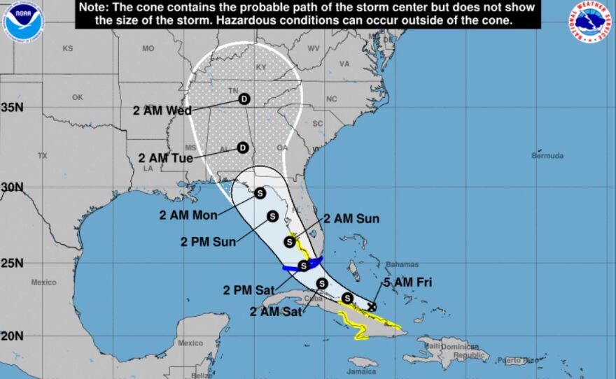
Weather watchers will be keeping an eye on the Gulf of Mexico as Tropical Storm Fred develops. The latest named storm of the 2021 season is expected to make a possible landfall on the Florida panhandle Monday morning. Alabama’s gulf coast could see heavy rain and winds from Fred. Jason Beaman is a meteorologist with the National Weather Service in Mobile. He says this is just the start of the busiest part of the Hurricane season.
“So, this just likely the first storm of many that we’ll at least have to watch," said Beaman. "And really, at this point, we ask people to get your hurricane plan ready. If you don’t a have hurricane plan for you and your family, now is the time to think about what you would do should a hurricane approach our area.”
The National Hurricane Center says TS Fred will be over the Florida Keys by Saturday afternoon, before it skirts the western coast of the the Sunshine State and reaches the panhandle Monday morning. As of this morning, Alabama's Eastern Shore remains within the storm's so called "cone of uncertainty," for feeling the effects of Fred. Meteorologist Beaman says now is the time to stay alert.
“At this point, we really ask people to keep in tune with the forecast," said Beaman. "Don’t check it once, and think it’s not going to impact you and don’t look again. Because that’s how some people get behind the curve, so to speak, with their planning and preparation.” Beaman says planning include an escape route in case of a coastal evacuation. He also warns about being ready for a long term power outage from a major storm.


