-
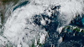 Hurricane forecasters are keeping an eye on the progress of Isaias. The system grew to tropical storm strength on Wednesday, and is expected to be a hurricane when it reaches anywhere form Gulfport in Mississippi, to Mobile, to Panama City Beach in Florida. The latest forecast has landfall expected sometime Friday Night. Before Isaias formed, APR student reporter John Underwood talked with three experts for tips on how to get ready for this year’s hurricane season. One special note—John’s story talks about preparing for evacuation.EDITOR'S Note— Local leaders in Gulf Shores and Orange Beach in Alabama are advising residents of low lying areas to voluntarily evacuate. In Florida, the Associated Press is reporting that some residents of RV parks in Gulf County and Okaloosa County (Zones A and B) are under a mandatory evacuation order.
 -
 Tropical Storm Bertha made landfall in Louisiana and was southwest of New Orleans while moving west toward Texas early Thursday morning, after closing beaches on the Gulf Coast from the Florida Panhandle to Mississippi.
 -
 Communities on the U.S. Gulf Coast distributed sandbags and closed beaches as Tropical Storm Bertha threatened to bring flooding and strong winds Wednesday from the Florida Panhandle to Louisiana.
 -
 Tropical Storm Bertha strengthened in the Gulf of Mexico and was moving slowly toward the Florida Panhandle, causing a tropical storm warning and storm surge watches around the state line between Florida and Alabama, forecasters said. The storm was about 125 miles south of Panama City, Florida, and 200 miles southeast of Mobile.
 -
 The National Hurricane Center in Miami reported the development of a tropical depression. The system appeared just west of Florida’s Tampa Bay. The current forecast has the depression becoming a Tropical Storm by Monday and moving west across the Gulf of Mexico. The system may brush by Mobile Bay on Tuesday and Wednesday before making landfall on Texas by the end of the week. Even as a rainmaker, the system could complicate things for Uvalde, Texas where heavy rains have already prompted flooding near Camp Mystic where an Alabama girl drowned in 2025.
 -
 The remnants of Tropical Storm Arthur battered parts of the southeastern United States with heavy rain and wind on Thursday, damaging buildings, downing trees and knocking out power as flash flood and tornado warnings were issued along the Gulf Coast. Drenching rain stretches from Central Alabama to Mobile and the Eastern Shore.
 -
 The National Hurricane Center is watching a cluster of storms along the Gulf Coast could become the first named tropical storm of the 2026 Atlantic hurricane season. The storms threatened to bring heavy downpours that could lead to dangerous floods across southern states including Texas and Louisiana.
 -
 As forecasters with the National Hurricane Center watch the progress of Hurricane Erin, weather watchers say the most powerful storms tend to form later in the year.
 -
 Hurricane Francine struck the Louisiana coast Wednesday evening as a dangerous Category 2 storm that rapidly knocked out electricity to more than 100,000 customers and threatened widespread flooding as it sent potentially deadly storm surge rushing inland along the northern U.S. Gulf Coast. The hurricane center said parts of Alabama, Mississippi, and the Florida Panhandle were at risk of considerable flash and urban flooding in coming days.
 -
 “National Preparedness Month” is recognized throughout September, and Governor Kay Ivey is urging all Alabamians to create a plan and be prepared before disaster strikes. This comes as Hurricane Francine is barreling toward Louisiana and an expected landfall.

Digital Media Center
Bryant-Denny Stadium, Gate 4
Box 870370
920 Paul Bryant Drive
Tuscaloosa, AL 35487-0370
205-348-6644
© 2026 Alabama Public Radio
Bryant-Denny Stadium, Gate 4
Box 870370
920 Paul Bryant Drive
Tuscaloosa, AL 35487-0370
205-348-6644
© 2026 Alabama Public Radio
Play Live Radio
Next Up:
0:00
0:00
Available On Air Stations


