-
 Alabama is preparing for the coldest air of the season.The National Weather Service has issued an Extreme Cold Warning for the Tuscaloosa Area as well as the Gulf coast from midnight to until noon on Sunday. The agency says Huntsville and all of north Alabama will be under a Cold Weather Advisory during that same time frame. The forecast, in general, is for bitter temperatures and gusty winds, which could make it feel as cold as four degrees below zero.
 -
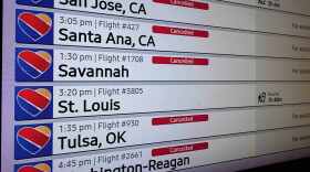 A massive winter storm set the stage for a brutal travel day Sunday, with airlines warning of widespread cancellations and delays at some of the nation's busiest airports. The disappointment of lost flights is being felt in Alabama as well. The website Flightaware says Huntsville International Airport had forty one cancellations as of this morning. Farther south, Birmingham Shuttlesworth International had forty seven.
 -
 Alabama Power Company crews are on standby for power outage repairs in north Alabama this weekend.Nearly two thousand utility crews are for deployment to portions of north Alabama this weekend.
 -
 Some of the first wintry weather of the season is on the way for much of the U.S. in the coming days, including potentially record low temperatures for parts of the South and snow in the Northern Plains. Alabama woke up in the upper twenties in Huntsville, upper forties in Mobile, and mid thirties over much of the rest of the state. Chillier conditions are yet to come.
 -
 As forecasters with the National Hurricane Center watch the progress of Hurricane Erin, weather watchers say the most powerful storms tend to form later in the year.
 -
 Snow is reportedly falling along the Tennessee Valley and that means the possibility of icy driving conditions in the coming hours. Forecasters with the National Weather Service in Huntsville say after the possible wintry mix or freezing rain, motorists should be on the alert for slippery conditions on roads and bridges tonight and into tomorrow.
 -
 The forecast calls for frigid temperatures and the threat of black ice on the roads this weekend. This is Alabama’s second arctic blast in just over a week. The last cold snap left up to seven inches of snow, closed schools, and delayed airline flights.
 -
 Freezing rain and sleet fell across portions of the Southeast into Tuesday morning. Winter storm warnings were in effect for Lawrence, Limestone and Madison counties in Alabama. Poweroutage.com reports just over six thousand (UPDATED) Alabama homes and businesses without power this morning.
 -
 A high impact weather system blew through central and southern Alabama overnight, prompting tornado warnings for Mobile and Baldwin Counties, heavy winds due to squall lines, and one of the two heaviest power outages nationally according to poweroutage.us.
 -
 Meteorologists across the state warn of the risk for severe weather this weekend. For some residents, this weather starts today. Weather experts are advising Alabamians to be aware of possible thunderstorms, damaging winds and hail.

Digital Media Center
Bryant-Denny Stadium, Gate 61
Box 870370
920 Paul Bryant Drive
Tuscaloosa, AL 35487-0370
205-348-6644
© 2026 Alabama Public Radio
Bryant-Denny Stadium, Gate 61
Box 870370
920 Paul Bryant Drive
Tuscaloosa, AL 35487-0370
205-348-6644
© 2026 Alabama Public Radio
Play Live Radio
Next Up:
0:00
0:00
Available On Air Stations


